
Construction Progress Reports
Aerial Documentation That Helps Keep Projects Clear, Organized, And On Track
Construction projects change quickly. Site work, framing, roofing, utilities, grading, staging areas, access roads, material deliveries, and subcontractor progress can all shift from week to week. Aerial construction progress reports provide a clear visual record of what is happening on site so owners, builders, project managers, investors, and stakeholders can stay better informed.

Our aerial construction progress reporting services use high-resolution imagery, video, and optional mapping-style deliverables to help document site conditions, track visible progress, improve communication, and create a useful project record over time.
Whether you need a one-time site overview or recurring progress documentation, aerial reporting provides a practical way to see the full project from a better perspective.
Why use aerial progress reporting?
Ground-level photos are useful, but they often miss the full picture. Aerial imagery helps show the relationship between structures, site access, staging areas, grading, drainage, equipment, neighboring properties, and overall project flow.
This can be especially helpful for:
- residential construction
- commercial construction
- land development
- grading and site work
- road and access improvements
- roofing and exterior phases
- solar, utility, and infrastructure projects
- multi-building developments
- remote owner updates
- investor or lender reporting
- before-and-after documentation
The goal is simple: provide clear, organized visual records that make project communication easier.
Benefits For Owners And Developers
See The Full Site At A Glance
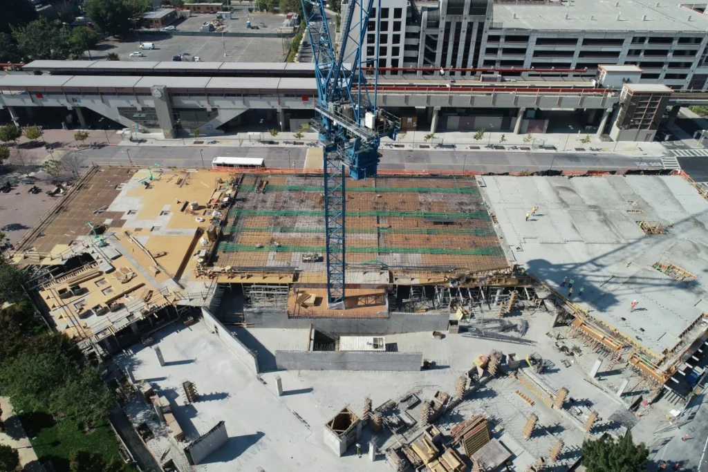
Aerial progress reports help owners and developers understand what has changed, what is underway, and how the overall project is taking shape. This is especially useful when the owner is not on site every day.
Improve Stakeholder Updates
Clean aerial photos, videos, and progress summaries can be used for owner updates, investor reports, lender communication, board presentations, and internal project reviews.
Create A Visual Project History
Recurring aerial documentation builds a timeline of visible progress from early site work through completion. This can be valuable for project records, marketing, dispute avoidance, and future planning.
Benefits For Contractors And Project Managers
Communicate Progress More Clearly

Aerial imagery gives project teams a shared visual reference. Instead of relying only on text updates or ground photos, teams can see the project layout, progress areas, access paths, staging zones, and site constraints in context.
Support Planning And Coordination
Aerial views can help document:
- grading and earthwork progress
- foundation layout
- framing and roof progress
- exterior work
- material staging
- equipment placement
- site access and traffic flow
- drainage and erosion control
- utility trenching and site infrastructure
- parking, roads, and laydown areas
Reduce Misunderstandings
A consistent visual record can help clarify what was visible on a specific date, where work was occurring, and how site conditions changed over time.
Benefits For Real Estate, Marketing, And Completed-Project Promotion
Construction progress imagery can also support marketing and business development. Builders, developers, contractors, architects, and property owners can use aerial visuals to show capability, document transformation, and create content for websites, social media, sales materials, and project case studies.
Useful marketing applications include:
- project milestone updates
- before-and-after visuals
- completed-project portfolios
- website and social media content
- sales presentations
- community updates
- investor-facing visuals
What We Can Help Document
Depending on the project, aerial progress reports can help document:
- pre-construction site conditions
- grading and earthwork
- road and driveway access
- drainage areas and erosion-control measures
- foundations and pads
- framing and structural progress
- roofing and exterior work
- utility trenching and infrastructure
- solar or equipment installations
- material staging and laydown areas
- parking lots and hardscape
- landscaping and final site improvements
- overall project completion

Typical Deliverables
Depending on the project scope, deliverables may include:
- high-resolution aerial photos
- short progress video clips
- full-site overview images
- side-by-side progress comparisons
- date-stamped image sets
- basic progress summary
- organized folders by date or project phase
- marked-up images highlighting key areas
- website or social-media-ready visuals
- optional orthomosaic maps for larger sites
- optional repeatable flight paths for consistent comparisons
Recurring reports can be scheduled weekly, biweekly, monthly, or around major construction milestones.
Recurring Progress Reporting
For many construction projects, the most useful approach is a recurring report from the same general viewpoints over time. This creates a consistent visual timeline that is easier to compare and share.
Recurring aerial documentation can help answer questions like:
- What changed since the last update?
- Which areas are active now?
- Are access routes, staging areas, or site conditions changing?
- What does the project look like from the owner’s perspective?
- How can we show progress to people who are not on site?
A Practical Reporting Service, Not A Replacement For Construction Management
Aerial progress reports provide visual documentation and site perspective. They do not replace licensed inspections, engineering review, survey work, safety management, or formal construction oversight.
They are best used as a helpful layer of visual communication that supports the people already managing the project.
Need a clearer way to show construction progress?
We would be happy to help with one-time or recurring aerial progress documentation for your project. Share a few details about the site, project phase, and how often you need updates, and we can recommend a simple reporting plan.